| NOAA Magazine || NOAA Home Page |
EMERGENCY
PERSONAL LOCATOR BEACON SYSTEM BECOMES
OPERATIONAL NATIONWIDE
 July
1, 2003 — Outdoor adventurers now have access to the technology used
in the lifesaving satellite-tracked distress alerts carried by aviators
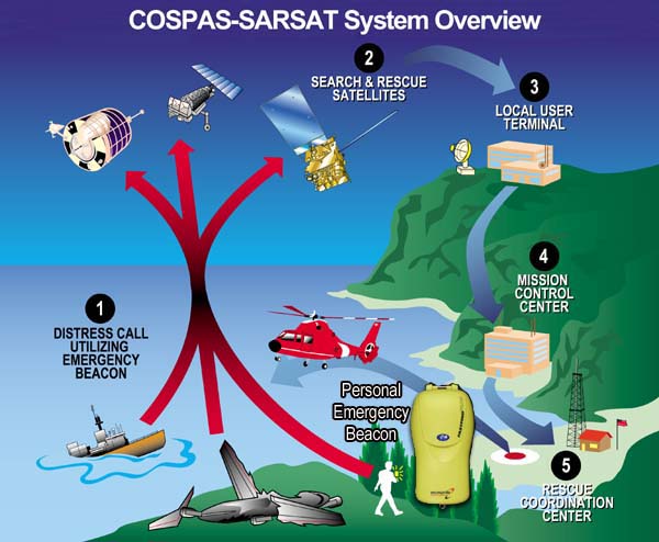
and mariners. Personal Locator Beacons (PLBs)
became operational on July 1st in the continental United States. (Click
NOAA image for larger view of Cospas-Sarsat system overview.)
July
1, 2003 — Outdoor adventurers now have access to the technology used
in the lifesaving satellite-tracked distress alerts carried by aviators
and mariners. Personal Locator Beacons (PLBs)
became operational on July 1st in the continental United States. (Click
NOAA image for larger view of Cospas-Sarsat system overview.)
The beacons emit a signal that can be tracked by a worldwide satellite search and rescue system when they are activated in an emergency. This signal is picked up by satellites operated by NOAA.
“Personal Locator Beacons save lives,” said retired Navy Vice Adm. Conrad C. Lautenbacher, Ph.D., undersecretary of commerce for oceans and atmosphere and NOAA administrator. “Their availability presents a significant public safety benefit for the millions of people in the United States who explore the nation’s wilderness every year.”
 The
new personal beacons have advanced features including global positioning
system (GPS) technology, which make it easier and quicker for NOAA
satellites to pick up distress signals and relay an accurate location to
rescuers. The signals are relayed to the U.S.
Mission Control Center at the NOAA Satellite and Information Center
in Suitland, Md., for processing. (Click NOAA image for larger
view of PLBs from various manufacturers.)
The
new personal beacons have advanced features including global positioning
system (GPS) technology, which make it easier and quicker for NOAA
satellites to pick up distress signals and relay an accurate location to
rescuers. The signals are relayed to the U.S.
Mission Control Center at the NOAA Satellite and Information Center
in Suitland, Md., for processing. (Click NOAA image for larger
view of PLBs from various manufacturers.)
In the United States, the PLB alerts are routed to the Air Force Rescue Coordination Center (AFRCC) at Langley Air Force Base in Virginia, the single federal agency for search and rescue in the 48 contiguous states. The AFRCC notifies the state rescue agency, or state police in the area where the PLB was activated.
“The AFRCC has many resources available to dispatch on a moment’s notice to aid in search and rescue efforts,” said Lt. Col. Scott Morgan, the Air Force Rescue Coordination Center commanding officer. “However, the desire is to use resources effectively, and PLB’s do that by pinpointing the location of the person in distress. The bottom line is we’ll be able to better locate individuals and save lives.”
The PLBs send out digital distress signals on the 406-megahertz frequency, which are detected by NOAA Geostationary Operational Environmental Satellites (GOES) and Polar-orbiting Operational Environmental Satellites (POES). GOES, the first to detect a beacon’s distress signal, hover in a fixed orbit above Earth and receive the signals, which contain registration information about the beacon and its owner. The POES constantly circle the globe, enabling them to capture and accurately locate the alerts.
The satellites are part of the worldwide satellite search and rescue system called, COSPAS-SARSAT. The COSPAS-SARSAT system is a cluster of NOAA and Russian satellites that work together to detect distress signals anywhere in the world from PLBs and beacons aboard ships and airplanes.
Personal Locator Beacons will be available at outdoor sports and electronic retail outlets across the country. All owners of PLBs and other types of 406-megahertz beacons are required by law to register them with NOAA. The registration includes critical information such as the owner’s name, address, telephone number and the PLB’s unique identification number. The distress signal is checked against a registration database, which contains information to locate the missing person.
“A PLB is an effective tool only if people take the time to register it,” Lt. Col. Morgan added. “With this information, the AFRCC can validate an alert with one phone call to the designated emergency contact, who can vouch for the whereabouts of the beacon’s owner.”
NOAA Satellites and Information is the nation’s primary source of space-based meteorological and climate data. It operates the nation’s environmental satellites, which are used for weather and ocean observation and forecasting, climate monitoring and other environmental applications, including sea-surface temperature, fire detection and ozone monitoring.
NOAA Satellites and Information also operates three data centers, which house global databases in climatology, oceanography, solid Earth geophysics, marine geology and geophysics, solar-terrestrial physics and paleoclimatology.
NOAA is dedicated to enhancing economic security and national safety through the prediction and research of weather and climate-related events and providing environmental stewardship of the nation’s coastal and marine resources. NOAA is part of the U.S. Department of Commerce.
Relevant
Web Sites
NOAA’s Role in the
Cospas-Sarsat Program
NOAA Satellites and Information
Personal Locator Beacons—Help From Above
International Cospas-Sarsat program
Media
Contact:
John
Leslie, NOAA Satellites and
Information, (301) 457-5005